
Why Hike the Larapinta Trail — And Should You Go Solo or Westbound?
The Larapinta Trail is one of Australia’s premier long-distance hikes — and for good reason. Stretching 223 km across Tjoritja / West MacDonnell Ranges, it combines rugged ridgelines, red rock gorges, waterholes, and ancient desert landscapes. But what makes it truly unique is its ability to offer both challenge and solitude — a trail that invites reflection as much as it rewards endurance.
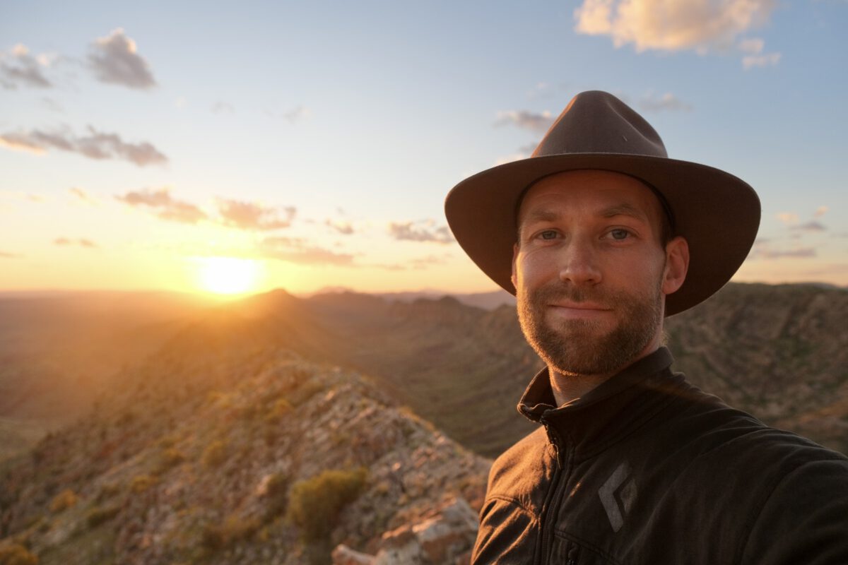
I chose to hike the Larapinta because it was the right trail at the right time: a long, wild walk to close out my Australian chapter. I’d done many solo hikes before — starting with the 8-day Malerweg (Germany) in 2013 — and I’ve since balanced that with trips shared among travel mates and years of professional guiding experience. I’ve seen hiking from all sides: personal, social, and professional. But for this one, I knew I needed to go solo.
As an introvert, I crave the stillness and space that solo trekking gives me — time away from the background noise of cities and other people’s energy. For others, the solitude may sound daunting, but if you’re looking for clarity, rhythm, and reconnection, this trail is a powerful teacher.
Should You Hike the Larapinta Solo?
Yes, if you want space to think, personal challenge, and a deeper connection to the landscape.
No, if you’re unsure about water management, logistics, or navigating in remote areas (though there are plenty of supported options and guided groups).
Also Yes, if you’re somewhere in between — experienced enough to handle yourself, but open to solitude’s lessons.
Hike Larapinta Eastbound vs Westbound — Which Way Should You Go?
| Eastbound (W2E, Redbank Gorge → Alice Springs) | Westbound (E2W, Alice Springs → Redbank Gorge) | |
|---|---|---|
| Trail Start | Remote — requires early transport | In Alice Springs — no transport needed to start |
| Trail End | Finish in town — easy access to food, bed, flights | Finish remote — need to prearrange pickup |
| Rutjupma / Mt Sonder Climb | Early on Day 1 or 2 | Climactic finish on final day |
| Afternoon Sun | At your back — cooler walking | In your face — warmer, brighter |
| Trail Flow | More common among guided groups | Slightly less common — quieter experience |
| Psychological Arc | Toward comfort, civilization | Toward wilderness, remoteness |
| Logistical Simplicity | Easier finish, fewer bookings at the end | More upfront planning, esp. exit logistics |
| Best for… | First-timers, supported hikers, those short on time | Solitude seekers, experienced hikers, reflective journeys — my reason |
When’s the Best Time to Hike Larapinta Solo? Why August Worked for Me
The best time to hike the Larapinta Trail is usually from May to September, when the Central Australian desert is dry, cool, and at its most walkable. For me, August wasn’t just ideal — it was perfect.
The landscape had come to life after earlier rains: waterholes held strong, tanks at campsites were full, and the desert was blooming back from fire, with fresh greens and flowering bursts everywhere. I had no issues with water availability, and the “cool”, clear days were ideal for long hours on the trail. Anyway, working as a Guide at Watarrka Kings Canyon for the past 4 months, helped me adapt to the climate and the terrain here.
But the timing worked for more than just trail conditions. August slotted perfectly into my broader travel plans. My Australian visa would run until March, but I had to be in Canada by September to activate my visa there — and an Outdoor Education expedition along the Great Ocean Road was waiting for me in early September. The Larapinta became a natural window — a way to close my Australian chapter with intention, clarity, and a long walk across ancient land.
I walked westbound, into the sun most afternoons. Others might avoid that — and sure, it meant more squinting — but it also made me stop and look back more often. Every glance reminded me of the ridgelines I’d crossed and the ground I’d covered. Timing, after all, isn’t just about weather — it’s about where you are in life, and what the trail gives you space to see.
Larapinta Trail Prep & Planning: From Pixels to Peanuts
Before setting a single foot on the Larapinta Trail, I had already walked it in my head a hundred times. Maps, spreadsheets, gear lists, and meal packs were all part of the adventure long before the red dust hit my boots. This chapter is for the over-preparers, the checklist junkies, and those who love geeking out over logistics just as much as the hike itself.
Gear for the Larapinta Trail Conditions
For this Larapinta thru-hike, I packed light — though not ultralight — prioritizing comfort, function, and gear I trusted. If I had one, I likely would’ve taken a 1-person tent, but in true “use what you’ve tested” fashion, I stuck with my Durston X-Mid 2P. Reliable, roomy, and familiar — and that peace of mind matters in remote terrain like this.
I carried enough water capacity for up to 6 liters, a small stove + titanium pot setup for essential evening cuppas, and my classic layering system for chilly mornings and sun-scorched afternoons.
My kit doesn’t change drastically between trips — just the add-ons depending on the terrain: a paddle float for kayak missions, extra insulation for alpine treks, or spare fuel for desert routes like this.
Food & Fuel Strategy for a Westbound Solo Hike
I planned for 3 food drops:
- Standley Chasm
- Serpentine Gorge
- Ormiston Gorge
Each box had 2–3 days of food, repacked into ziplocks to save bulk and weight. Meals were a mix of:
- Back Country Cuisine & Radix freeze-dried dinners
- Instant oats, cereal, and trail mix
- Boiled eggs, biltong, dried veggies
- And let’s not forget: hot chocolate spiked with ginger, vanilla, or chai spices — worth every gram.
Some meals flopped (looking at you, reheated pasta mush with crushed egg), but others like the BC Moroccan Lamb and Radix 800 Chili absolutely slapped.
Food planning was powered by a spreadsheet that tracked days, meals, drops, and even caloric panic. Water planning was just as detailed — tracking known refill points, consumption rates, and buffer litres for dry stretches.
I chose to drop the boxes myself and made a full day of it, soaking in the views along Namatjira Drive, which forms part of the stunning Red Centre Way.
If you don’t have your own vehicle, you can get your boxes dropped off by the awesome team at:
The same crew who later provided my transport back. Their website is also one of the best resources out there for planning your trek.
Mapping the Madness: Navigating the Larapinta Trail
Forget following the herd. I downloaded the official NT Parks topo maps (see under “Sections of the Larapinta Trail“), chopped them into manageable print sections, and marked key terrain features, camps, and waterholes manually.
- Paper maps for peace of mind
- Garmin Descent MK2i with GPS & GLONASS
- the first days in UltraTrac setting to save battery life, but it tracked everything underestimated (go figure), so I made made my own setting then
- Garmin synchronized to Strava to log & share notes later
- also, for my data loving brain
Larapinta Route & Schedule Planning
Based on the spreadsheet I built (and obsessed over), each day was broken down by:
- Sections covered
- Estimated hiking hours
- 5 km/h pace + 500 m/hr elevation gain — based on my personal fitness. Yours might differ. International average is 3 km/h + 300 m/hr elevation gain.
- Distance & Ascent
- Campsites & alternative Options
- Water availability
- Sunrise/Sunset + Daylight times
You can view my full daily plan here — every nerdy detail from km walked to when to eat and where to refill water.
Budget Breakdown
Here’s what it cost me to walk the Larapinta Trail solo, westbound and unsupported:
| Item | Cost |
|---|---|
| NT Parks Camping & Walking Fee | AU$ 225 |
| Pick-up Transfer | AU$ 380 |
| 3x Food Drop Fee ($95 each) | AU$ 285 |
| Food (to be added) | ??? |
| Taxi to Standley Chasm | AU$ 152 |
| Total (so far) | AU$ 1,042 + food |
Some things (like the $152 taxi to skip fire-closed sections) weren’t planned — but that’s part of the journey. So is buying two focaccias, a smoothie, a mint Magnum, and a Kirks Pasito the second you hit Ormiston Gorge. You’ll understand when you get there.
Solo Trail Mindset Before the Larapinta
Honestly, I was over-prepared on some things (hello 2 uncooked eggs at Ghost Gum Flat) and underprepared on others (like not checking the weather or knowing where fires were). But I also allowed room for freedom — to walk longer days when I felt strong, or nap under a tree when I didn’t.
I went in wanting solitude, reconnection with land, and a bit of a mental reset. The Larapinta gave me all that — and some stunning views, weird dreams, painful blisters, and unforgettable encounters with fellow wanderers.
Bonus if you’re doing this too:
- Print your own maps — it’s grounding.
- Use your spreadsheet. But don’t be ruled by it.
- Bring hot drink options. Always.
- And pack a third pen.
Saturday · August 12, 2023
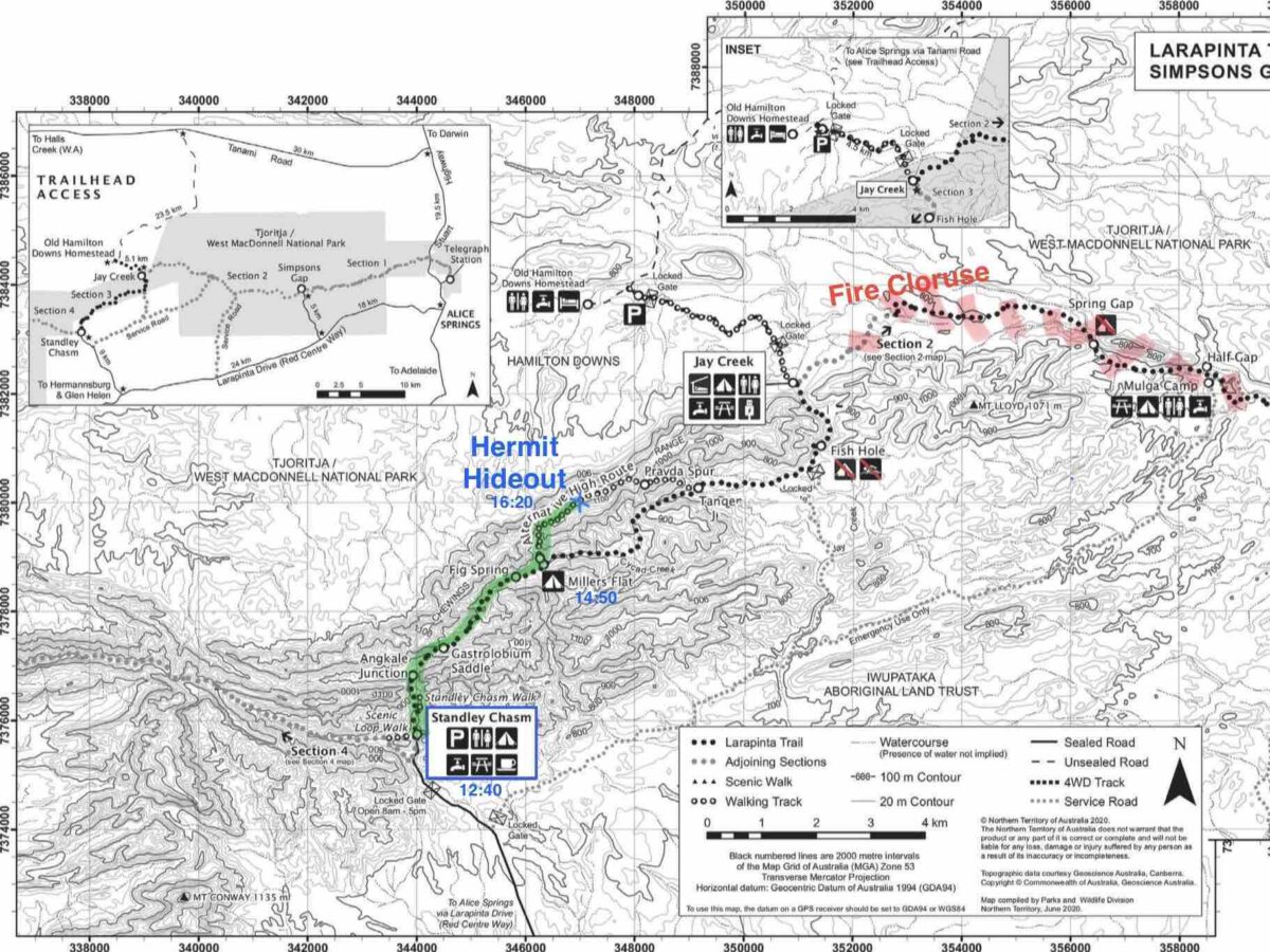
Larapinta Day 1:
Alice Springs to Hermit Hideout via Standley Chasm
| Distance | ~17.9 km (8.93 km + ~9 km) |
| Sections | 1 & 2 closed (skipped by taxi), began Section 3 (Standley Chasm to Pravda Spur) |
| Start / End | 08:00 – 16:20 |
| Camp | Hermit Hideout (unofficial site) |
| Weather | Warm, not as hot as expected, light breeze |
| Expenses | $152 taxi from Alice Springs to Standley Chasm |
| Meals | Lunch at Standley Chasm café |
| Water Refill | Not recorded (assumed refill at café) |
👣 Trail Notes & Reflections
Didn’t check the weather forecast, but it turned out to be milder than expected. Warm, light breeze, no wind at the summit. The real surprise? Sections 1 & 2 of the Larapinta were closed due to fire. A helpful woman at the Telegraph Station gave me the heads-up, which led to an unexpected but necessary $152 taxi ride to Standley Chasm on the Namatjira Drive / Red Centre Way.
After a decent café lunch, I started hiking westbound into Section 3, taking the high-route via the Pravda Spur. Met three trail runners doing recon for a Fastest Known Time attempt — they were prepping for Piotr Babis’ run, which would happen a week later (FKT here).
The walk was cruisy, the pack felt alright, and I ended up staying at a spot known affectionately among Larapinta trailblazers as “Hermit Hideout.” A hidden gem passed on by word of mouth — quiet, flat, and full of character. That night, I realized I was already two days ahead of schedule. Thinking I might use the bonus time to linger longer at Ormiston Gorge. Or just nap somewhere under a gum tree and call it type-1 hermiting.
Sunday · August 13, 2023
Day 2: Hermit Hideout to Brinkley Bluff
| Distance | ~17.5 km |
| Sections | Section 3 (Pravda Spur to Standley Chasm), Section 4 (to Brinkley Bluff) |
| Start / End | 08:40 – 16:50 |
| Camp | Brinkley Blufff – W ridge (past summit cairn) |
| Weather | Clear skies, evening glow on the ridge |
| Pack Weight | ~25 kg after Standley Chasm food drop (incl. 2 extra days of food + 8L water) |
| Meals | Lunch at Standley Chasm, Dinner on summit |
| Water Refill | Standley Chasm shelter (drinking + cooking + electrolytes) |
| Trail Highlights | Big ridge views, Dusty Sisters, blister discovery, sunset scramble for photos |
👣 Trail Notes & Reflections
Left Hermit Hideout at 08:40 with a fairly light load — just enough water to get me to Standley Chasm for a relaxing lunch and resupply. I arrived by 11:10, picked up my first food drop, topped up all water bottles, and left again around 12:50 — now carrying about 25 kg, including 8L of water (3L + 2.5L drinking + 2.5L cooking).
The afternoon climb up to Brinkley Bluff was long and exposed but beautiful. The Larapinta followed a Razorback Ridgeline with grand views over the Tjoritja / West MacDonnell Ranges all the way — the kind of landscape that makes your feet sore but your brain buzz.
I arrived at the summit cairn around 16:50, but instead of setting up where most people do, I wandered further — out past the main summit area, beyond where the trail begins its descent down the south face. I pitched camp along the west ridge, slightly isolated but perfectly positioned to soak in the late sun.
Not long after, the Dusty Sisters arrived and camped near the summit cairn. We shared a few laughs and some trail stories, and they tipped me off about other hikers I might meet soon — Paul, and a loud crew affectionately nicknamed the Camp 5 Boyband.
While prepping dinner, I couldn’t help myself — the light was just too good. I grabbed my Fujifilm X-T4 and spent the golden hour darting around camp, chasing angles and shadows with a restless urgency. I can never sit still when the light is perfect. Dinner got cold — but the photos? Worth it.
Back at camp, I finally sat down to eat and noticed something nagging in my left toe — a fresh blister, pushing under the nail. I opened it up carefully, gave it some air, and hoped for the best.
Used about ½ L for cooking and hot drinks, plus another ½ L for electrolytes. The wind had calmed, the ridge glowed, and despite the sore feet and delayed dinner, I felt perfectly at home. Tomorrow’s plan? Probably push for Hugh Gorge Junction, if the mood and feet agree.
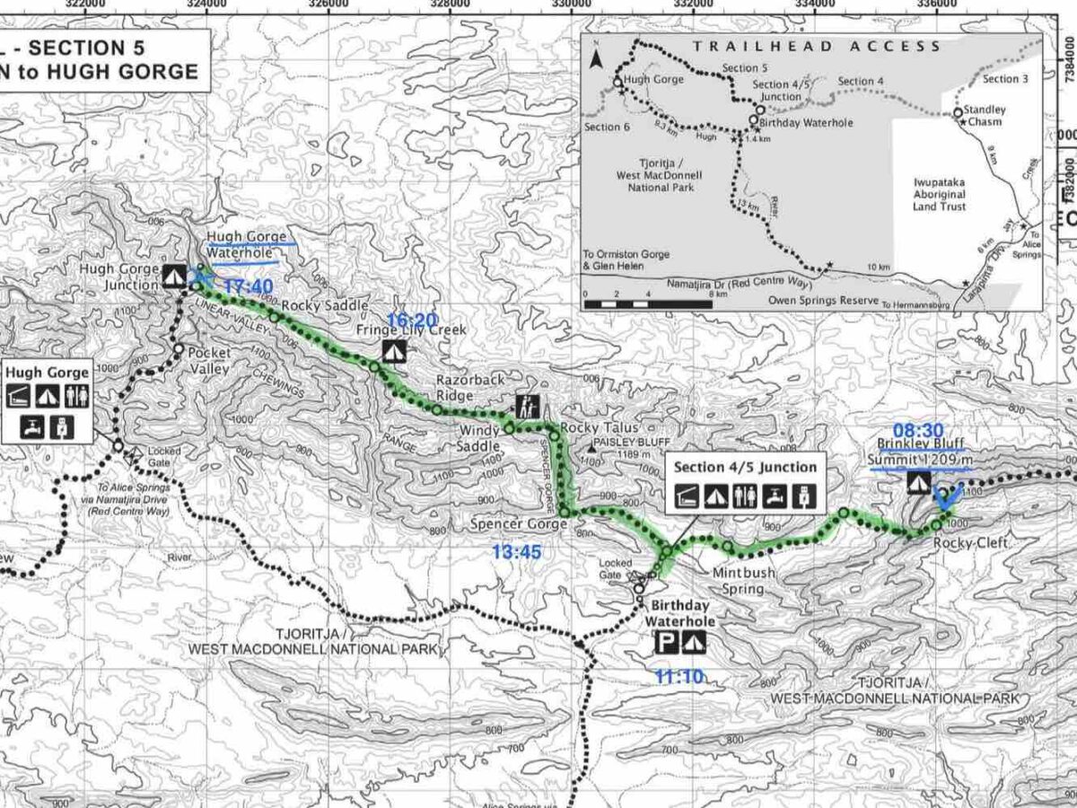
Monday · August 14, 2023
Day 3: Brinkley Bluff to Hugh Gorge Junction
| Distance | ~20.2 km (est.) |
| Sections | Section 4 (Brinkley Bluff to Birthday Waterhole), Section 5 (to Hugh Gorge Junction) |
| Start / End | 08:30 – 17:40 |
| Camp | Sandy patch between Hugh Gorge cleft and junction |
| Weather | Sunny, cool shade in gorges, breezy high points |
| Blister Status | Old blister improving — no new ones |
| Meals | Lunch at Fringe Lily Flat, Dinner at camp |
| Water Refill | Birthday Waterhole, Rocky Gully |
| Trail Highlights | Budgies at Jackson’s Pass, razorback ridge, “Camp 5 Boyband,” icy swim attempt |
👣 Trail Notes & Reflections
Took a relaxed morning on Brinkley Bluff — packed up slowly, soaking in the summit stillness. I hit the trail by 08:30 and only got about a third of the way down when I met Paul, making his ascent. We chatted briefly — he eyed my shoes and asked if they weren’t too soft for this kind of trail. I was still happy with them at that point, but yeah… in hindsight, he had a point. Heavy pack weight does squash cushioning quickly. That’s why real backpacking boots are so stiff — but I still prefer the freedom.
The Larapinta leads down to a lush waterhole in Stuart’s Pass, where bursts of green and yellow birds popped out of nowhere — budgies! I love spotting them wild here; they always remind me of my childhood pet birds back home.
Soon after, I met the long-awaited Camp 5 Boyband, camping at the shelter between Sections 4 and 5. Birthday Waterhole was just a few hundred metres off-trail, so I took a quick dip. Not warm, and not exactly clean, but definitely bracing.
Next came Spencer Gorge — dramatic sculpted rock and towering ridgelines. Spotted another trail runner (what’s with those folks lately? I’m jealous!) descending the talus field at the gorge’s end — likely smashing a big mileage day, running light and fast.
I pushed past Fringe Lily Flat, where I met three older hikers, and continued on to Hugh Gorge. Toward the end, it narrows into a deep cleft reminiscent of Redbank. There’s a cathedral-like stillness there — and a waterhole that looked like it would require some swimming and climbing to get deeper. I didn’t go all the way in, but a splash rinse was refreshing and cleansing enough.
I found a perfect sandy campsite about halfway between the waterhole and the official junction — nearly flat, soft, and quiet. Cooked dinner as the sky faded, no new blisters today (yay!), and the toe was doing much better.
Tuesday · August 15, 2023
Day 4: Hugh Gorge Junction to Ellery Creek North
| Distance | ~33 km (according to Strava) |
| Sections | Section 6 |
| Start / End | 08:00 – 19:40 |
| Camp | Ellery Creek North (stargazing tent setup) |
| Weather | Cool shaded gorge morning, hot exposed afternoon |
| Blister Status | New blister on left forefoot (opened and improved overnight) |
| Meals | Lunch at Ghost Gum Flat, Nap at Rocky Gully, Dinner at camp |
| Water Refill | Rocky Gully |
| Trail Highlights | Pocket Valley climb, ghost gum lunch, eggs survived, budgie swarms, Tjoritja / West Macs views |
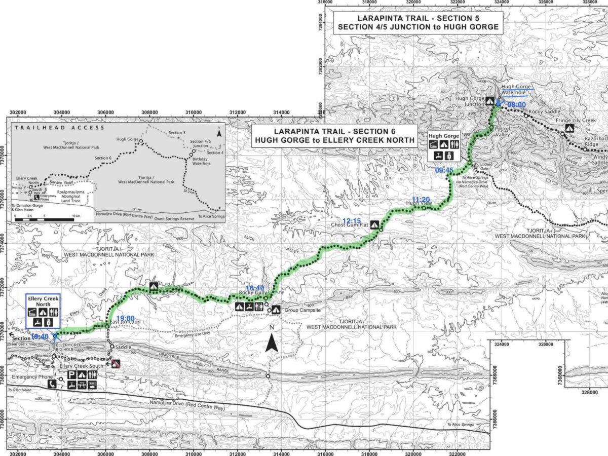
👣 Trail Notes & Reflections
I knew this would be a long day, and somehow I still left Hugh Gorge Junction late — around 08:00. Not far into the trail, I reached the waterhole at Pocket Valley — wide, deep, and wedged between steep rock faces. From here, you have two choices: go for a cold swim, or find a way to climb around it.
I took the more adventurous climb route, carefully making my way up and around the gorge walls. It was one of those moments where everything clicked — balanced, focused, dialed in. On the other side, I crossed paths with four hikers coming from the west. They’d camped at Hugh Gorge Shelter and asked how I got through the section. I gave them a grin and a “You’ll be fine — have fun!”
The section between Pocket Valley and the shelter was equally beautiful — long stretches of sandy trail, red glowing rock, and massive flocks of budgies flashing through the air like confetti in the wind. A full-on sensory treat.
At Hugh Gorge Shelter, I met a French hiker and used the break to charge my phone for a bit and, well, handle some backcountry bathroom business. After that, I pushed out into the wide, open valley.
What came next was not mentally tough at all — in fact, it was one of the most energizing stretches of the Larapinta. Despite the long distance and heat, I felt like I was blossoming in that landscape. Every turn brought something new: a lazy lizard soaking up sun, a lone wildflower standing tall, a spider’s web strung between two burnt shrubs, a bird silhouetted on a rock layer that looked drawn with a ruler. It was pure desert curiosity mode, and I loved it.
The wide valley opened out to big views of the Tjoritja / West MacDonnell Ranges — sunlit, vast, humbling. This is what I hike for.
At Ghost Gum Flat, I stopped for lunch and a 10-minute nap. That’s when I discovered two uncooked eggs still bouncing around in my bag. Miraculously unbroken. They got eaten on the spot.
In the afternoon, I paused at Rocky Gully Camp, totally wiped. Took a proper 30-minute nap in the shade of the water tank, refilled water, and pushed on. I arrived at Ellery Creek North after dark — not totally tired, but content.
I set up my tent in stargazing mode for the first time — no fly, just the mesh inner — and crawled in beneath a sky bursting with stars. A small blister on my left forefoot made itself known, but I drained it gently and it was already better the next morning.
The day had been long, but so full of small wonders that it never really dragged. One of those where your body wants to stop, but your spirit just keeps moving.
Wednesday · August 16, 2023
Larapinta Halftime — Day 5: Ellery Creek North to Serpentine Gorge
| Distance | ~12.5 km (Ellery North → West Junction → Serpentine Gorge) |
| Sections | Section 7 (partial) |
| Start / End | 14:20 – 17:30 |
| Camp | Serpentine Gorge (food drop area) |
| Weather | Cold morning, sunny afternoon, windy in the gorge |
| Blister Status | None — feet in great shape |
| Meals | Breakfast at tent & shelter, Lunch at Ellery Creek, Dinner at camp |
| Water Refill | Ellery Creek, minor top-up at food drop (assumed) |
| Trail Highlights | Skinny dip, butterflies in the gorge wind, new profile selfie, sunset lookout view |
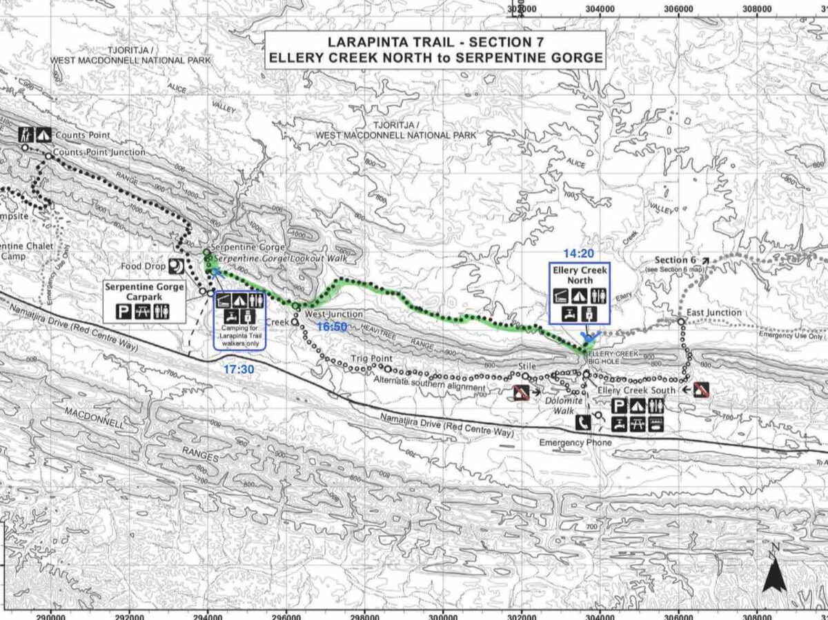
👣 Trail Notes & Reflections
Cold morning at Ellery Creek North. I slept in as long as I could before the sun turned my tent into a sweatbox. Cooked breakfast by the tent, but eventually moved to the shelter to escape the heat. A big group of 7 hikers + “forgot-her-name” arrived from Serpentine — a loud mixed crew.
I took a walk down into Ellery Gorge, following the sandy creek bed to a shaded corner. The water was way too cold for a swim, so I just sat and watched peewees and butterflies struggling in the wind funneling through the gap. Felt meditative.
Later I wandered upstream where the trail crosses a shallower waterhole — warmer, algae-lined, but good enough for a quick skinny dip. Rinsed off the sunscreen, grime, and sweat. One of those “reset” moments.
Back at camp I had lunch and a long nap. Then came a decision: instead of grinding out another full day tomorrow, I’d push on now to Serpentine Gorge and break things up into shorter days. Best call I could’ve made.
Left at 14:20, reached West Junction by 16:50, then continued to Serpentine Gorge, arriving just before sunset. Caught the golden light on the lookout above the gorge — steep climb but totally worth it. A vast, cinematic view over the Tjoritja / West MacDonnell Ranges.
The earlier group had warned me about the toilet situation, and yeah… it was rank. I wasn’t surprised.
Took the long walk to the food drop box (should’ve brought my torch — made it just in time, without having to use light on the way back). Discovered I’d packed double the pasta I needed 😅 and that the glass jar of tomato sauce was… unnecessarily heavy. Rookie move.
Couldn’t bring myself to leave trash at Serpentine, so I made a new plan: I’d carry the box and rubbish out to Ormiston and see if I could dispose of it there. Extra weight, sure, but it felt right. Slept well under clear skies, with that feeling you get after making a good choice and following through.
Thursday · August 17, 2023
Day 6: Serpentine Gorge to Counts Point
| Distance | ~8.5 km (approx.) |
| Sections | Section 8 (partial) |
| Start / End | 09:45 – 13:00 |
| Camp | Counts Point |
| Weather | Clear skies, sunny, expansive views |
| Blister Status | Opened 2nd blister properly, relief during walk |
| Meals | Lunch: 2/2 pasta & sauce, 2/2 Thai chicken curry, 300ml water + 300ml hot choc with vanilla; Dinner: ½ BC Moroccan Lamb, peas, mushrooms, potato mash, 300ml water |
| Water Refill | Full refill at Serpentine Gorge (bladder + 1.5L bottle) |
| Trail Highlights | High ridge walk, echo cliff, panoramic summit, solo songs |
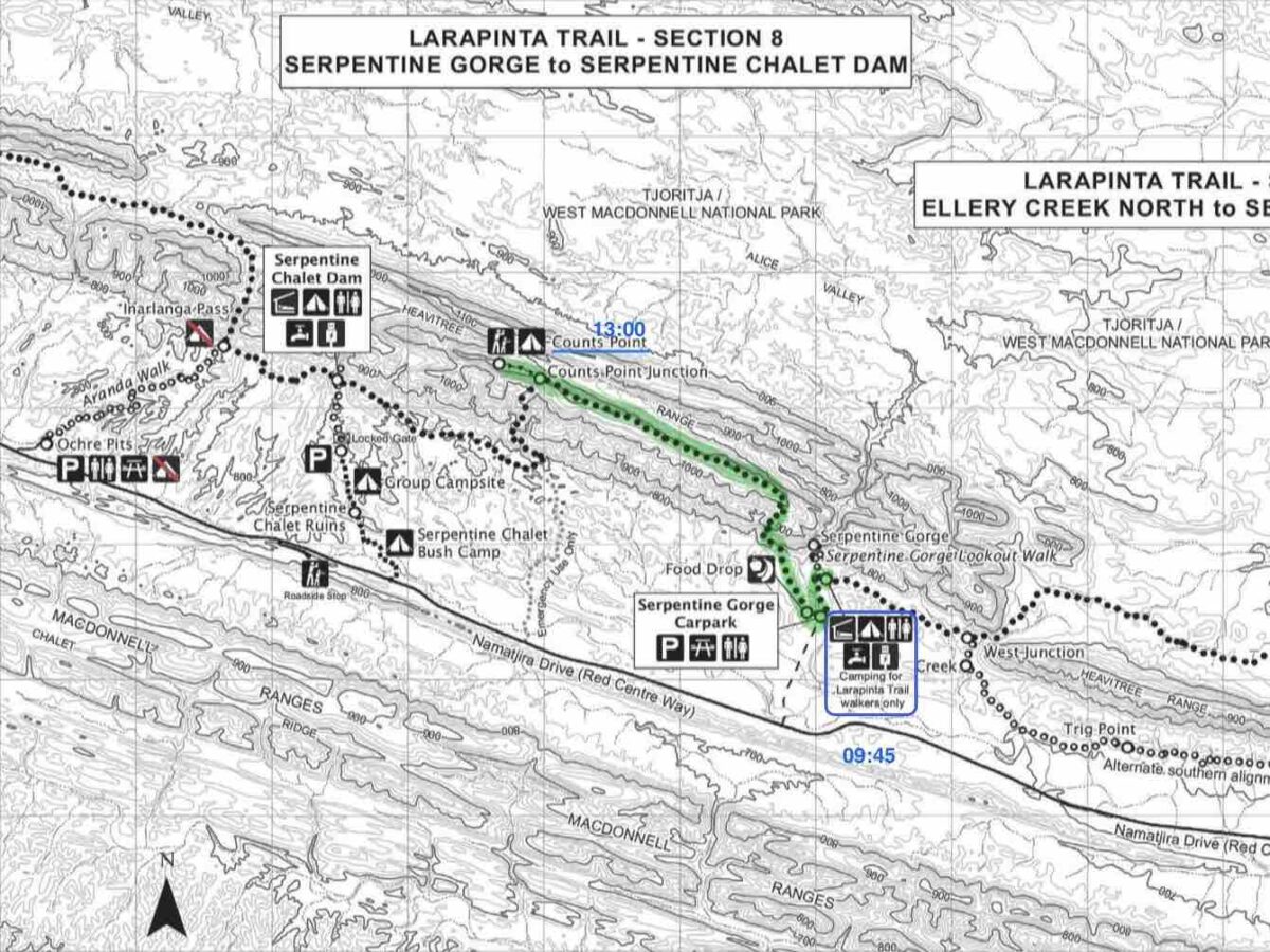
👣 Trail Notes & Reflections
Woke up knowing I had a big view day ahead — but first: blister surgery. Opened up the second toe blister again in the morning, this time properly. Cut out the top skin to create a hole that would drain rather than seal and refill. Immediate relief. In hindsight, no wonder yesterday hurt so much — it wasn’t just soreness, it was full of pressure again.
Packed up, but the pack felt weird. Heavy, but off-balance. Turned out the box lid was pressing oddly against the inside of the pack. No need to strap it — it fit well on top. Solved my empty bottle problem by sliding it head-down into the trekking pole holder, then bungeeing it tight with the pole top strap. Nice little hack.
Left Serpentine Gorge at 09:45, and the walk up to Counts Point was short but full of humbling views. Flowers, lazy lizards, and birds — funky ones, flashing through the spinifex. The track traced the rim above Serpentine Gorge, with wild views over Tjoritja / West MacDonnell Ranges and one spot where an echo bounced back after five seconds from a massive wall across the gorge. Unreal.
Reached Counts Point at 13:00, and just… soaked it in. This is by far one of the best viewpoints on the Larapinta. You can see it all:
- Tnorala / Gosse Bluff
- Rutjupma / Mt Sonder, Ltharrkelipeke / Mt Giles, and the long plains between
- Brinkley Bluff, the far trail line, and beyond to Hermannsburg
- All under this endless, breathing sky
Had lunch up top — the second half of yesterday’s pasta with sauce + Thai chicken — then pitched my tent, had a nap, took some photos, and just sang into the wind for no one in particular.
Dinner: First half of my Back Country Moroccan Lamb with some freeze-dried peas, mushrooms, and potato mash, plus a hot cuppa before sunset.
Set my alarm for 5:30am to catch the light and get ready for another short day tomorrow, so that I might be able to enjoy some of the afternoon again — off the edge and into the Tjoritja Ranges again.
Friday · August 18, 2023
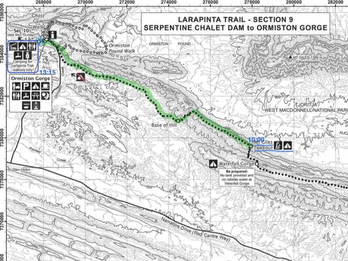
Day 7: Counts Point to Mt Ltharrkelipeke / Giles Lookout
| Distance | ~17.5 km (Counts Point → Ltharrkelipeke / Mt Giles Lookout via Chalet Dam & Waterfall Gorge) |
| Sections | Section 8 (remainder) + Section 9 (partial) |
| Start / End | 07:45 – 16:50 |
| Camp | Ltharrkelipeke / Mt Giles Lookout |
| Weather | Sunny, open skies, light breeze |
| Blister Status | All good! No new issues, feet felt solid |
| Meals | Beakfast: Cereal mix with pineapple, blueberry quick oats, 300ml water; Lunch: 2/2 BC Moroccan Lamb, 2 fresh boiled eggs, 300ml water + 300ml hot choc with vanilla; Dinner: Radix 800 Chili, peas, mushrooms, potato mash, 250ml water + 300ml hot choc (spiced ginger) + 300ml iso drink |
| Water Refill | Serpentine Chalet Dam (bladder + 2 × 1.5L bottles + 600ml Powerade bottle) |
| Trail Highlights | Counts Point descent, Inarlanga Pass, echo cliffs, rock scramble to summit |
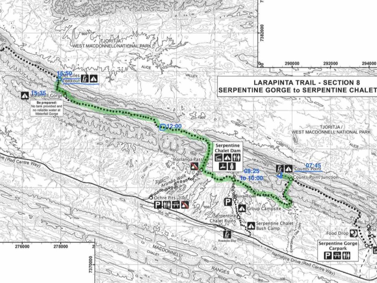
👣 Trail Notes & Reflections
Left Counts Point at 07:45, riding that ridge high. The descent was smooth and speedy — it felt like flying. Though honestly, some of the switchbacks made me think there might’ve been a more efficient route down…
After that, the landscape turned ochre. You could tell this was Country, not just geology. All around were pits dug from hillsides, bright earth everywhere — signs of ochre gathering.
At Inarlanga Pass, the rock layers looked like they’d been bent and smashed by time. There’s something spiritual about it — not in a cheesy way, but like the land is a portal between stories. Old ones.
The trail opened into what I call the Half Pipe Valley — burned country, with schist slabs jutting out like the ribs of the earth. Charred but recovering.
Stopped at an unnamed waterhole around midday — shady tree, just wide enough to nap under. So I did. Lunch was the second half of my BC Moroccan Lamb, two boiled eggs, hot chocolate with vanilla spice. Peace in a bowl.
After that, the trail flattened out a bit — not as exciting — until I reached Waterfall Gorge. It would’ve lived up to the name with a bit of rain. Today: just a small pool, a last refuge for bugs, and some dramatic rocky drops.
The final climb to Ltharrkelipeke / Mt Giles Lookout was more of a scramble in parts — steep, zigzagging, but fun. Took my time and saved energy. Hit the summit around 16:50, legs buzzing but steady.
Met Jose, my new camp neighbour — French, lives in Brisbane, and had a Durston 1P tent like mine. We got chatting. He’s out here because his mother-in-law has done the Larapinta five times and swore by it. Legend.
Set up camp just in time for sunset. The light was gentle and golden, and everything below glowed like it had been lit from inside. Short day tomorrow, yes! Ormiston Gorge awaits.
Saturday · August 19, 2023
Day 8: Ltharrkelipeke / Mt Giles Lookout to Ormiston Gorge
| Distance | ~11 km (Ltharrkelipeke / Mt Giles Lookout → Ormiston Gorge) |
| Sections | Section 9 (partial) |
| Start / End | 10:00 – 13:15 |
| Camp | Ormiston Gorge Campground |
| Weather | Warm and sunny, perfect for a reward day |
| Blister Status | No new ones, feet recovered |
| Meals | 2x Focaccia + smoothies, Snacks: Magnum, Powerade, Pasito, Dinner skipped |
| Water Refill | Full refill at Ormiston |
| Trail Highlights | Gorge recon, rock wallaby sightings, solo scramble, epic shirt wash, “ghost watch band” return |
👣 Trail Notes & Reflections
Left Ltharrkelipeke / Mt Giles Lookout at 10:00, thinking the day’s hike would be a breeze — but somehow it still tested my patience. I was racing downhill, ready for food, comfort, and a moment to stop moving… and it still felt longer than expected.
Arrived at Ormiston Gorge Campground around 13:15, and you better believe I went straight to the kiosk:
- $19.50 – Focaccia (HTCG) + mango smoothie
- $22.50 – Focaccia (veg salami + sardines!) + berry smoothie
- $17.50 – Magnum mint, Powerade Gold, Kirks Pasito
- $20.00 – Camp fee
Worth every cent.
After setting up my tent, I thought I’d finally relax at the waterhole… but I couldn’t sit still. Instead, I scouted the crossing for tomorrow’s Ormiston Pound walk. The main pool had one short deep section, but I found a way to walk around it and only wade knee-high.
Of course, I couldn’t leave it at that — I had to find a scramble route. Proud to report: I found one. A leaning wall that offered a surprisingly easy climb (yes, even in thongs). I was cautious, took my time, and just as I topped out, startled a rock wallaby — the first of two for the day.
Coming down was harder. Just when I thought I’d have to loop all the way back, I found a mini chasm leading to a rock fall — like a secret staircase. Mission accomplished.
Then I crossed to the other side of the gorge, found a steeper but easier-angled wall, climbed that too, and spotted rock wallaby #2. As I got my camera out, it vanished. Classic. I continued up through spinifex to Ghost Gum Lookout, where you can look straight down on the swimmers and out over the entire gorge. Unreal views.
Back at camp, I finally got my third food drop — pasta, yes please — and had the first real shower in 6 days. Washed my shirt, rinsed off the grime. I swear my skin looked tanned until I saw myself in the mirror — just dust and sweat. But best of all: the ghost watch band was back on my wrist. Glorious.
I didn’t even feel hungry for dinner — still full from the feast earlier. My site was next to a commercial “pack-free” walking group, who had clearly carried zero weight and 100% leftover energy. They were noisy. So were the three talkative girl hikers. I couldn’t imagine walking the trail alongside that chatter. I just smiled quietly to myself, knowing I had walked westward alone, in silence and serenity, while almost everyone else was going east.
Sunday · August 20, 2023
A Day Off from Larapinta:
Ormiston Gorge Pound Walk
| Distance | ~8.5 km (Ormiston Pound Circuit) |
| Sections | Side trail (Pound Walk, not part of Larapinta core) |
| Start / End | 12:45 – 16:55 |
| Camp | Ormiston Gorge Campground |
| Weather | Warm and sunny, calm and open |
| Blister Status | None — feet resting and happy |
| Meals | Breakfast in tent, kiosk lunch, Pasta for dinner |
| Water Refill | Campground taps |
| Trail Highlights | Flowering desert hibiscus, regrowth from fire, grey herons, gorge rock architecture |
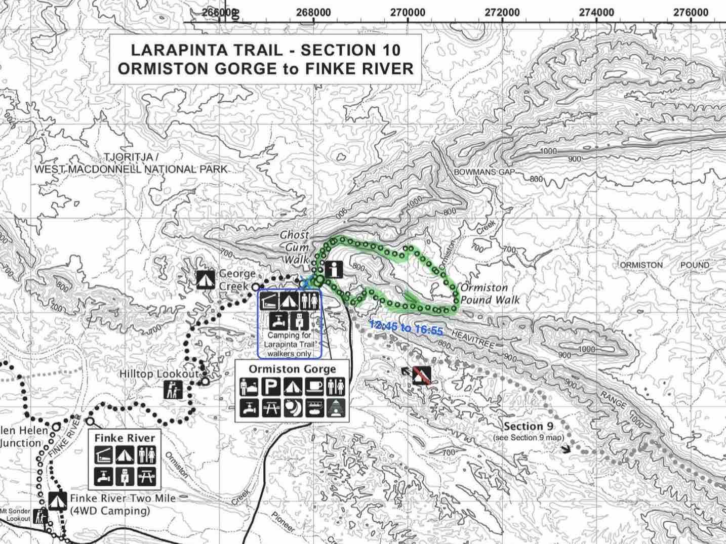
👣 Trail Notes & Reflections
Slept in — for real this time. My watch said over 9 hours, even if most of it was light sleep with a few midnight exits from the tent. Still, having a day off from the early routine was gold.
I took just as long to get up as I did to sleep — slow breakfast from the comfort of my sleeping bag and camp chair, inside my spacious tent. Oats, coffee, and no rush whatsoever. I love this setup.
The morning disappeared into the black hole of photo transfers. My camera kept freezing mid-process, and I had to reselect batches like six times. Frustrating. Eventually gave up and went for lunch — another focaccia at the kiosk, obviously. I was sitting at the only power socket table, so I made the most of it to charge everything.
In the afternoon, I headed out on the Ormiston Pound Walk — a scenic loop I’d scoped the day before. The start of the trail wasn’t overly exciting, but the cliffside stretch above the river had some great views, and the trail was dotted with blooming desert hibiscus (technically wild cotton, but I still call them desert roses). They’re one of my absolute favorites.
From the Pound Lookout, the scene opened wide — reminded me a lot of Wilpena Pound in the Ikara–Flinders Ranges back in SA. Inside the pound, the signs of recent fire were everywhere — scorched trunks, blackened earth, and already, bursts of green regrowth. So many legumes, wildflowers, and surprises in bloom. Nature bouncing back, full color palette on display.
Down in one of the big river bends, I was stoked to see so much water still pooled up, guarded by grey herons stalking quietly. With predators like those around, it’s no easy life being a fish in the desert.
The final stretch through the gorge felt like walking into a story written in stone — the whole landscape buckled, cracked, and peeled back over time. You could see the layers of pressure and collapse like a slow-motion explosion frozen mid-frame. A literal slice through geological time. It’s a place that always makes you feel small — in the best way.
Back at camp, I had a simple pasta dinner, no appetite for anything fancy. I felt content — today had been full in a different way. A zero in kilometers maybe, but not in wonder.
Monday · August 21, 2023
Day 10: Ormiston Gorge to Hilltop Lookout Camp
| Distance | ~17.5 km (Ormiston → Finke River → Hilltop Lookout) |
| Sections | Section 10 (partial) |
| Start / End | 09:00 – 15:25 |
| Camp | Hilltop Lookout |
| Weather | Warm and sunny, shady summit camp |
| Blister Status | No issues |
| Meals | Breakfast: Giant bowl of cereal; Lunch: Pasta with leftover sauce, dried veg, 1.5 eggs; Dinner: Radix 600 Smokey BBQ, smoked biltong + sunset cuppa |
| Water Refill | Presumably Finke River or carried |
| Trail Highlights | Finke River green zones, solo camp on summit, peaceful nap |
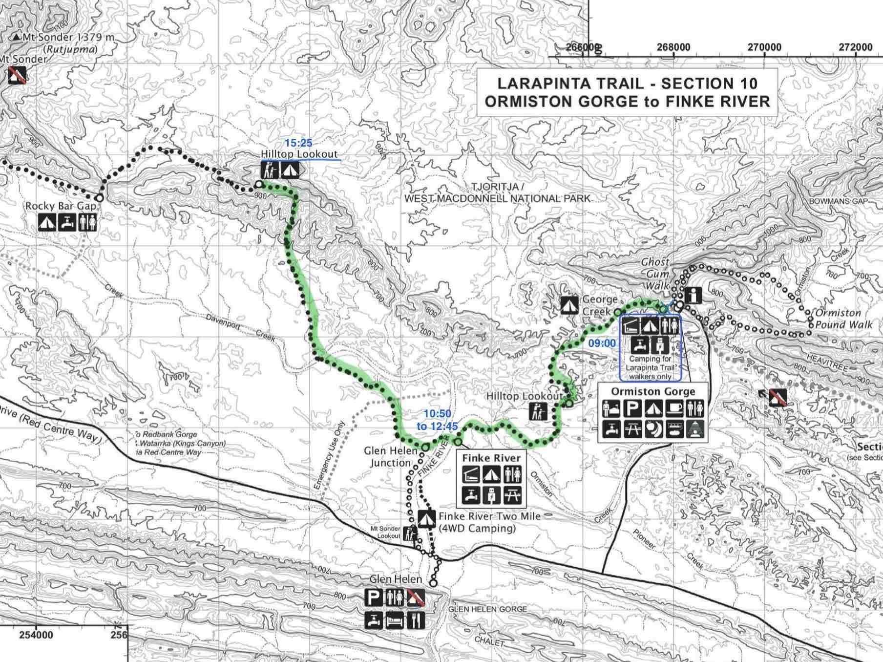
👣 Trail Notes & Reflections
I thought I was off to an early start, but after a giant bowl of cereal and the usual packing chaos, I didn’t leave Ormiston Gorge Camp until 09:00.
Honestly, the trail today didn’t quite deliver. The views weren’t new anymore, and the birds and plants I saw I’d already seen plenty of. So I went into auto-hike mode — legs on, brain off — and let my thoughts run wild. Last night’s dream was epic and now playing back in my head like a blockbuster at prime time.
Reached Finke River Camp at 10:50, took a break, and left again around 12:45 after a truly underwhelming lunch. It was the worst trail meal so far: leftover pasta with some dried veg and one-and-a-half eggs (I finally smashed one in my food bag — milestone unlocked 🙌🏻). To top it off, the sauce mesh held heat so well I burned my tongue. Brilliant.
Still, the Finke River held more water than expected, which gave the valley a lush feeling. But strangely, not many birds — maybe too much water in one spot means they’re spread out instead of concentrated like around small waterholes.
Arrived at Hilltop Lookout Camp by 15:25. It’s got the most summit camping spots I’ve seen so far, but I had the place to myself. Found a shady site — not the best for views, but perfect for a nap. Bull ants nearby, but they seemed to keep to their lanes. A few curious ones wandered into mine, but no trouble.
Pitched the tent, rolled out the mattress, and passed out in the shade. Woke up in time for dinner and a sunset cuppa — tonight it was Radix BBQ + biltong, and the evening glow did the rest. An early night for an early summit start tomorrow.
Tuesday · August 22, 2023
Last Day on Larapinta — Day 11: Hilltop Lookout to Redbank Gorge & Rutjupma / Mt Sonder Sunset Summit — A Farewell to Australia
| Distance | ~19 km total (Hilltop → Redbank Camp + Rutjupma / Sonder return hike) |
| Sections | Section 11 + Rutjupme / Mt Sonder Out & Back |
| Start / End | 07:25 – 19:50 |
| Camp | Redbank Gorge Campground |
| Weather | Warm, calm, late-day glow |
| Blister Status | Feet holding up fine |
| Meals | Breakfast: CerealLunch: Final pasta portionDinner: Radix 600 Smokey BBQ + smoked biltong |
| Water Refill | Redbank Gorge |
| Trail Highlights | Rutjupma / Sonder summit (solo at sunset), real summit traverse, running descent |
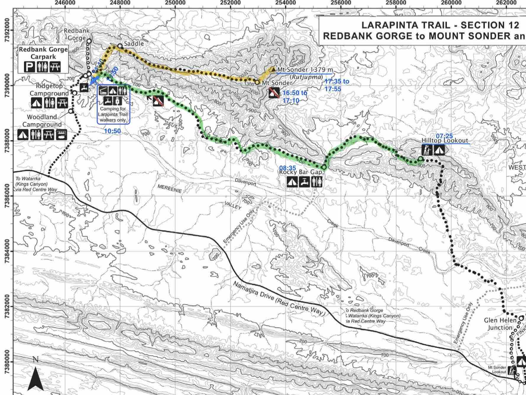
👣 Trail Notes & Reflections
Left Hilltop Camp at 07:25, descending into the valley surrounded by Rutjupma / Mt Sonder. The first stretch to Rocky Bar Gap was peaceful, but the last few kilometers to Redbank Gorge felt kind of underwhelming — maybe just familiarity kicking in. I pushed through quickly, basically counting down the kilometers, and arrived at Redbank Camp by 10:50.
With time to spare, I pitched my tent, cooked up some lunch (my final sad serving of pasta), and tried to nap, but I couldn’t sit still for long. Rutjupma / Sonder was waiting.
At 14:40, I left for the summit push — a late start by trail standards, but that was the plan. Sunrise had been done already, years ago. Today was about sunset. I moved fast up the track, taking quick breaks in the shade. The climb felt strong, familiar.
At the tourist summit cairn, I met Danny — already up there, snacking. We chatted briefly, shared the view. But I couldn’t stay long. I needed to get to the real summit.
I’ve been here before — twice, actually:
- The first time, I climbed for sunrise with an American girl. She was content with the tourist cairn, but I had to reach the true summit. Of course I did. Didn’t even track it with my Garmin Fenix 3 for some reason.
- The second time, in July 2023, I only went to Rutjupma / Sonder Lookout, then bush-bashed west through the scrub to the rim of Redbank Gorge — breathtaking to see it from above. That was also just after I’d summited Mt Zeil, and seeing Zeil from Rutjupma / Sonder completed a mental loop.
First time I stood here, I eyed Zeil and thought: That looks impossible. Now I know it’s not.
And this time — this was it. The last hurrah.
Not just of the Larapinta, but of my whole time in Australia.
I scrambled along the narrow spine above the gulf between the cairn and the true summit. The light was lowering, the silence deepening. I didn’t mind the late hour — I’d had the sunrise moment before.
This was sunset’s turn.
Sat at the top. Snacked. Looked. Let it all hit me.
I’d worried this trip might leave me anxious — that the finality of it all would feel unbearable. And in a way, yes — it hurts. More than leaving the Great Barrier Reef, even though I loved that place deeply. But back then, it wasn’t goodbye to a country. It was hello to something new.
This?
This was closure.
This was letting go.
And yet, sitting there — alone, surrounded by all that ancient rock and ridge — it felt like peace.
A good goodbye.
I left the summit around 17:55, back past the cairn at 18:20, and started running. I passed Danny on his way down, and kept flying.
Downhill is my element.
Moving fast and fluid through this terrain — that’s a joy I’ll never be able to explain properly. Hiking lets you see the fine details, yes. But running? That’s dancing with the landscape.
I only needed my head torch after clearing the tougher sections. Ran the rest back to Redbank Camp, arriving at 19:50. And that was it.
The Larapinta Trail.
The Red Centre.
The Outback.
Australia.
Tomorrow: just a ride back to Alice Springs.
Then south.
Then onward.
But tonight, the story ended exactly where it was meant to.